Neighbors Pan the Plans—Back to the Drawing Board?
Developers Target Brotherhood Way
• • • • • • • August 2025 • • • • • • •

Finally, the long-awaited plans for improvement of the Brotherhood Way Corridor from the San Francisco County Transportation Authority (SFCTA) have arrived. It is important to note that SFCTA is a County agency that administers transportation funds from the half-cent sales tax imposed by Prop K in 2003. The San Francisco Metropolitan Transportation Authority (SFMTA) is a City Agency. They are separate entities; each has its own administrative structure, policies, staff, budget, and borrowing capacity. The presentation by David Long addressed the traffic solution for Brotherhood Way, the major thoroughfare that joins the westside of San Francisco with the east. It is essential for many residents here and beyond. Sadly, many were disappointed with the three different solutions. Thinking back, I remember the public comments regarding saving the Oceanview Library at the foot of Orizaba Avenue. SFCTA's traffic solution now seems laughable. All three solutions — A, B, and C — were conceived with the library in mind.
BROTHERHOOD WAY TO BE DEVELOPED?
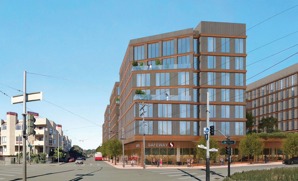
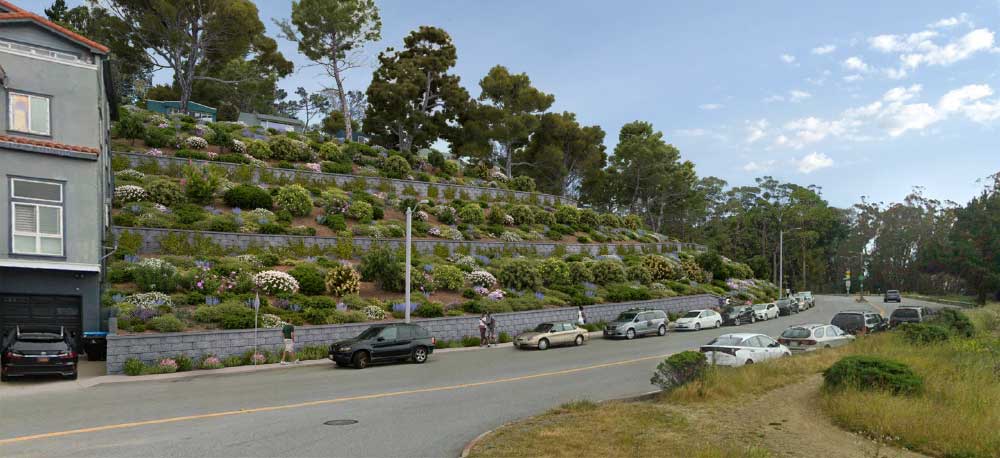
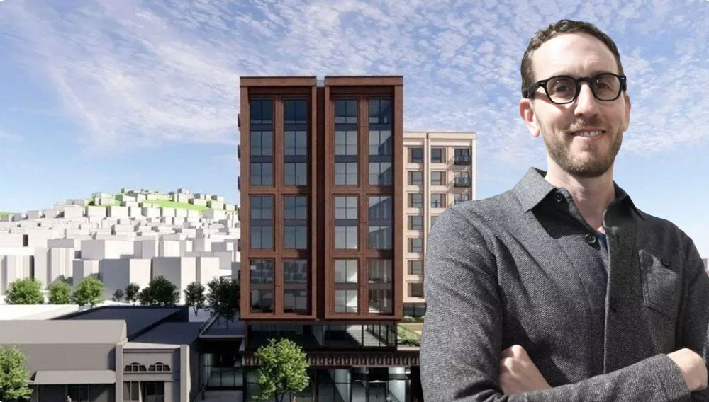
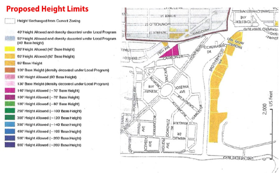
George Wooding received a handout at a Planning Department meeting entitled the PROPOSED ZONING MAP DRAFT, April 2025. It outlined the desire to develop an 8-story housing complex along Brotherhood Way at the foot of Brotherhood Blvd. beside Lake Merced. This information surprised METNA members, who were not informed about this plan for development.
Incidentally, historically, Stanley Creek, which was located on this site, presents as subsurface water that makes the Brotherhood Way Greenbelt prone to liquefaction. No doubt, this Greenbelt is the reason the Planning Commission has denied developments over the decades. Andrew Sohn, an SF architect, explained that any library built on the Greenbelt would require extra pilings, an additional expense added to any residential units built there. The question is, would the Planning Department turn a “blind eye” to shortfalls of earthquake safety here?
THE INITIAL PRESENTATION
The presentation began in a very polished manner, but did not continue that way. When Solution C was discussed, all that was displayed was unreadable masses of color, with no detail of the solution present. At the time, many were alarmed that Long’s presentation was the only information that was provided about Solution C. There were no sections or elevations of this solution. The Audience completely missed the magnitude of this project.
After the initial presentation by Senior Planner Long, no questions were allowed. The public was completely in the dark on Solution C.

THE FLAWED RESEARCH METHOD
Those in attendance wondered if SFCTA had predetermined the outcome to fit their desired conclusion.
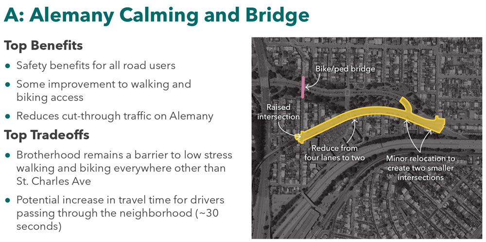
SOLUTION A
The thrust of the design of Solution A is to reduce traffic along Alemany Blvd. and make this into a neighborhood street.
THE INITIAL PRESENTATION

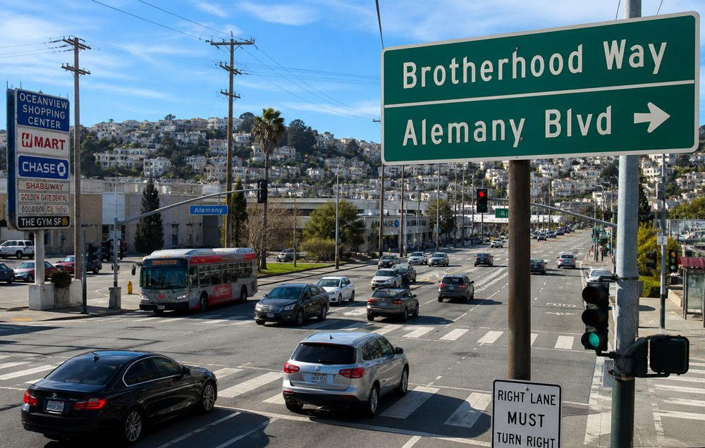
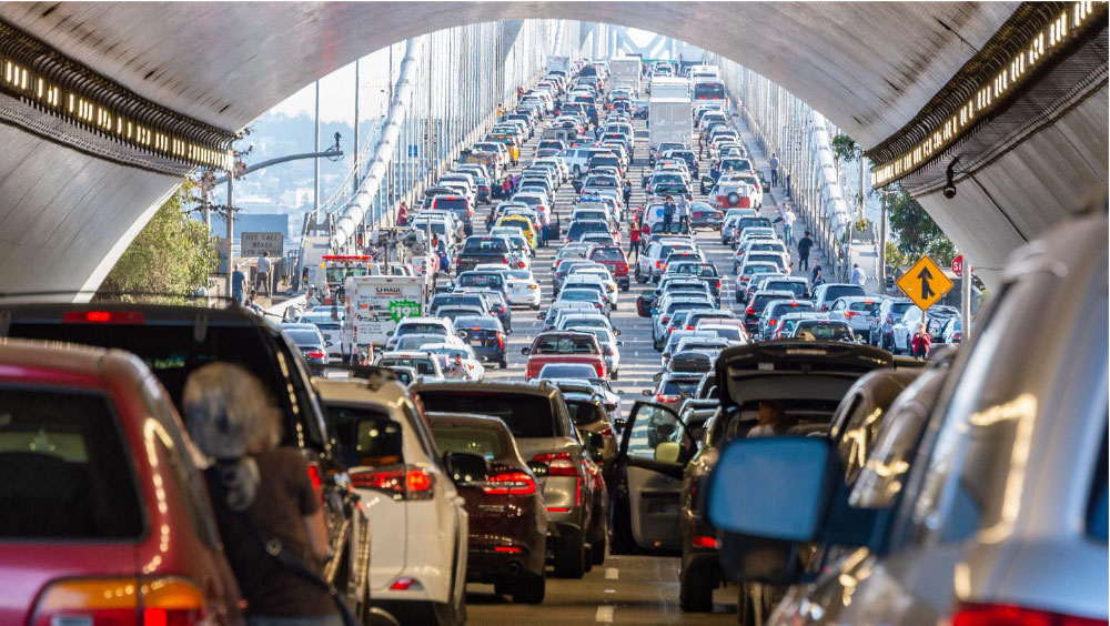
To achieve this, SFCTA would eliminate two-lane traffic in each direction and make Alemany Blvd. into a one-way street in each direction. This solution ignores the fact that the Oceanview Village Shopping Center was recently recognized as a successful mall in San Francisco. Strangling traffic to this business would be “killing the goose that laid the golden egg.” Piling risks on the mall risks more loss of small businesses. No doubt, 47% of business vacancies have already contributed to the decline of downtown San Francisco, perhaps due, in part, to the denial of vehicular traffic on Market Street. Denying traffic to businesses could decrease employment in the neighborhood.
Consequently, MUNI regularly delivers passengers to the BART station nearby. The 54, 57 and 58 buses frequently use Alemany Blvd. Moreover, the entrance to the 280 Freeway makes this solution problematic for everyone in the Merced Extension Triangle Neighborhood Association (METNA) district and half of the entire population of the Oceanview, Merced, and Ingleside district (OMI). To dream of Alemany Blvd. as a quiet and calm neighborhood street is to overlook reality.
To name just a few of the businesses and destinations on Alemany Blvd. that would be impacted by one-lane traffic are: Chase Bank, Hmart, Paris Baguette (bakery), Extreme Pizza, Subway, Seven Leaves Cafe, AT&T Store, AAA insurance office, the dog park, and Alder Landscape Architecture. Even more important are the numerous residents living at the Oceanview Village Condos, representing 370 units. Does this sound like a candidate for becoming a quiet neighborhood street?
If you close off one lane, you cannot have all these necessary amenities in one place.
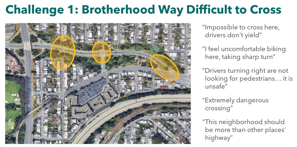
The notion of a raised pedestrian bridge at St. Charles and Brotherhood Way is unnecessary; few serious injuries occur there. If you want to provide a pedestrian bridge, place it at Brotherhood Way beside Alemany Blvd., where most accidents and injuries occur. Instead, SFCTA proposes an awkward turn with only a signal light to make the location safe.


The claim that additional “green space” is added in Solution A ignores the already present median, which is green space itself. This talking point has no real substance.

After the initial presentation by Senior Planner Long, no questions were allowed. The public was completely in the dark on Solution C.”
The claim that if they disturb the traffic on Alemany Blvd. and Brotherhood Way, commuters could find an opportunity to use side streets to hasten their commute shows poor research. The developer who designed and built Orizaba Avenue long ago provided no side streets. In his greed, this developer added housing where a street should be. Traveling from east to west in this neighborhood, no side streets allow an escape. The only street available for traveling east/west is Broad or Randolph Street, on which the M streetcar slows the traffic to 3-5 mph. There are no side streets that will reduce the burden of traffic on Alemany Blvd.
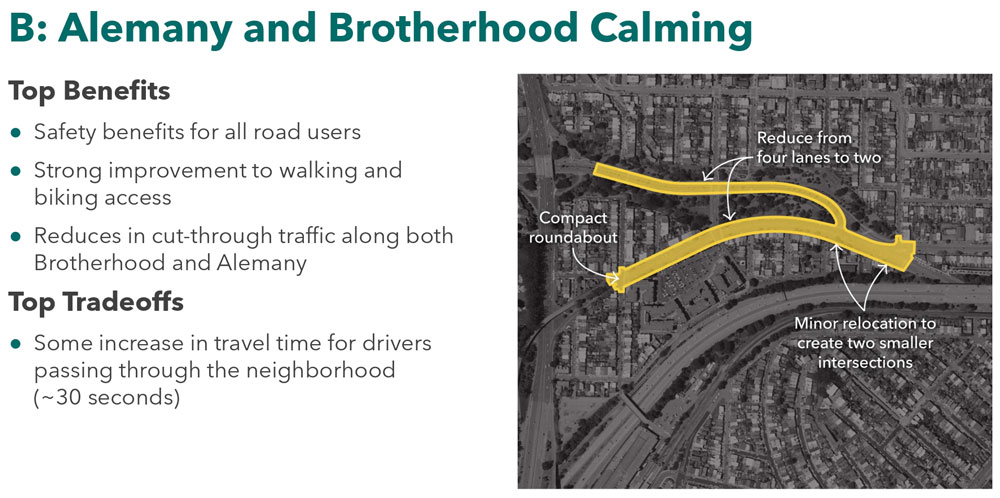
SOLUTION B
Again, the claim that drivers will find alternative routes if the SFCTA’s plan to reconfigure the traffic pattern in the neighborhood is misinformed. To declare that traffic would move to John Daly Blvd., San Jose Ave., or I-280 is unsound. First, John Daly Blvd. provides a north-south commute and does not facilitate east/west movement. San Jose Avenue turns into Mission Street, then El Camino Real, as it travels east to west. This path is fine if you are traveling to Daly City; unfortunately, commuters in San Francisco would likely want to travel to Districts 1, 2, 4, 7, or 11. This solution showcases a lack of understanding of the traffic patterns in the OMI and Merced Extension Triangle districts.
This solution also reduces the lanes from two to one on Alemany Blvd. Recently, the Chronicle reported that two malls in San Francisco are booming with business as downtown languishes. Those malls are at Stonestown and the Japan Center.
Nearby destinations on Brotherhood Way include the Parkmerced Shopping Center at Cambon Drive, which has a grocery store, a Budget Rental, a laundromat, Hall of Flame (hamburgers), Brochette Dumpling, and many more.
Let us not forget Sisterhood Gardens, which runs beside Brotherhood Way.
To get to the Stonestown Mall from the east part of the City, one has to use Brotherhood Way. Again, the SFCTA plan would complicate the ability to travel to the Stonestown Mall by limiting two lanes to one lane. The perceived advantage — to create a bike lane is redundant. There is already a bike lane there. The other justification is to the hope that it would calm traffic and make Brotherhood Way into a neighborhood street. What SFCTA is proposing strangles a satisfactory transportation route.
Overshadowing this, parts of nearby Stonestown will be developed by Brookfield Properties into a major residential development — 5.700 additional units — requiring additional services. Is limiting the lanes from two to one a good idea?
Since Parkmerced is considered the second-largest residential development west of the Mississippi, does it reduce the ability to travel home to these condominiums and apartments?
Those living in the Sunset and the Richmond district must also travel on Brotherhood Way. Minimizing the lanes means it will take longer for these San Franciscans to get home.
Those who travel on Brotherhood Way have no alternative transportation route, to or from the Oceanview, Ingleside and Merced (OMI) district. This is because Orizaba Avenue has no cross streets.This transportation plan does not work.
SOLUTION C

This is the most ambitious plan of the three provided. It changes the alignment of Brotherhood Way to enter the Greenbelt beside the presently existing “dog park.” Since SFCTA has provided no elevations or sections, it is unclear to the public how dramatic the changes would be. Tens of thousands of yards of soil would need to be excavated and moved in this solution. Again, this solution proposes one east and west lane on the new Alemany Blvd. and Brotherhood Way configuration. An important advantage of this solution is the creation of 4.8 acres of new Greenbelt.
Presently, a long line of cars enters this thoroughfare at Brotherhood Way. Planner Long misinformed the public on the delay this solution would provide. Moreover, since I live across the street from this intersection, I have not seen a traffic study counting the number of cars during rush hour, concluding that this design is poorly researched, satisfying the management of SFCTA or the Planning Department. As a landscape architect, this solution will turn Brotherhood Way into the same congested thoroughfare as Ocean Avenue, where a long line of cars awaits entrance into their district from Highway 280.
Today, there are only three east/west thoroughfares into Districts 7 and 11. They are Monterey Blvd., which takes you close to West Portal but is already over-congested. The second east/west thoroughfare is Ocean Avenue, which has the K streetcar, which limits the space available for automobile traffic and is also overly congested. Lastly, the remaining east/west thoroughfare is Sagamore/Brotherhood Way, or the project proposed here. The configuration works adequately with two lanes available to travel east/west on Brotherhood and Alemany Blvd. Reducing this thoroughfare to one lane in each direction would snarl traffic. SFCTA’s belief that traffic would go elsewhere belies poor research.
BICYCLE COALITION INVOLVEMENT?
There were a number of young people present at IT Bookman on July 15, 2025, who were not from the neighborhood. Is it possible that members of the Bicycle Coalition were there to influence the results of the Brotherhood Way Safety and Circulation Study? Many residents of Merced Extension Triangle (MET) believe so. Most of those who live here in the MET neighborhood do not endorse this solution.
STANLEY CREEK
Historic Stanley Creek is revived in this solution, which is essential since the creek begins where the Oceanview Library was suggested to be built. Theoretically, if you endorse this plan, a library at that location is excluded.
The development shown in the Proposed Zoning Map, Draft April 2025 will occur west of Junipero Serra Blvd., where numerous churches are located.
PEDESTRAIN BRIDGE
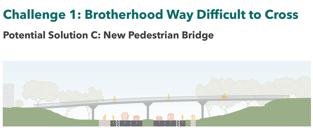
The long and overly expensive pedestrian bridge proposed at St. Charles and Brotherhood Way in Solution A is unnecessary since few injuries have been reported there. Instead, a pedestrian bridge is necessary where numerous injuries occur, at Brotherhood Way and Alemany Blvd. intersection. Thus, there is no need for a stoplight, allowing traffic to be unhampered as it travels east/west and reducing the extremely expensive grading required to implement the realignment of the Alemany Blvd./Brotherhood Way thoroughfare in Solution C. In the past, a pedestrian bridge here was considered too expensive. However, suppose the SFCTA is willing to design a bridge at St. Charles Street, where it is not needed. In that case, that is twice as long and twice as expensive, then a pedestrian bridge at Alemany/Brotherhood Way is not too exorbitant and should be considered.
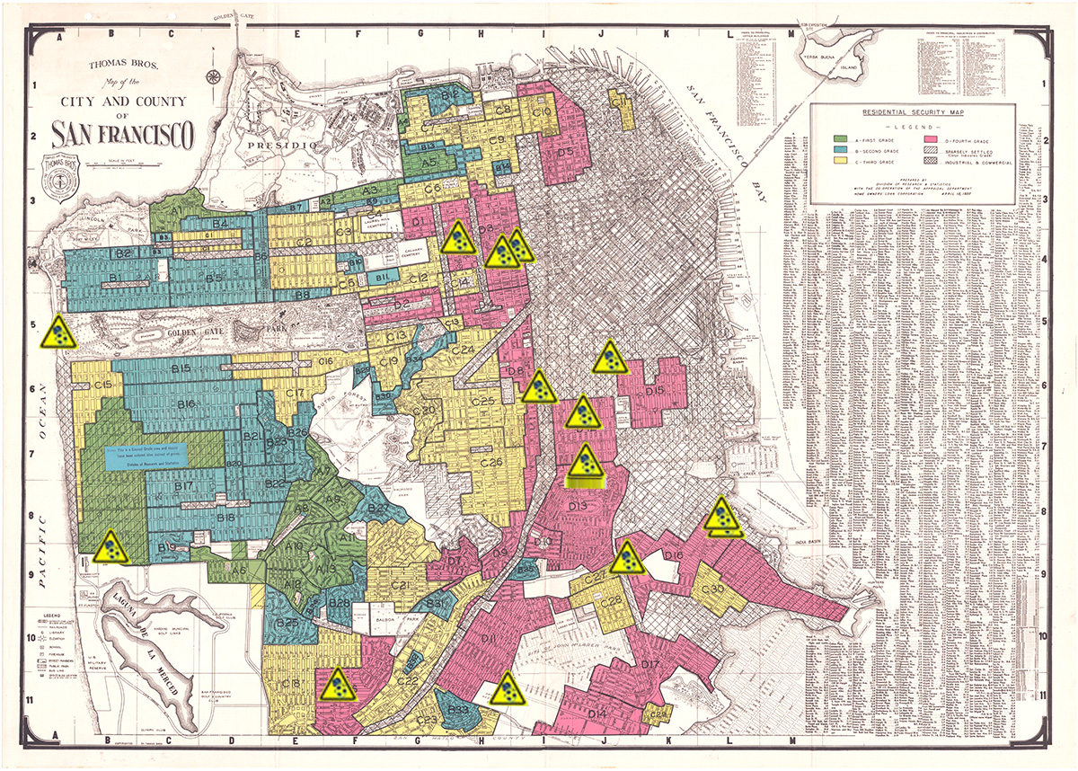
THE MAP BELOW IS OF THE PROPOSED ZONING MAP: DRAFT APRIL 2025
As you can see, this map indicates the desire to build 80-85-foot housing on the Brotherhood Way Greenbelt. Are the plans presented by the SFCTA and David Long a clandestine precursor to this development?
George Wooding, Coalition for San Francisco Neighborhoods (CSFN) President Emeritus,
Glenn Rogers, CSFN Chair, Open Space Committee
August 2025